 |
Collaborative Work Systems Inc.Engineering Human Centered Collaborative Systems for Complex Work Environments |
|
Collaborative Work Systems Inc.Engineering Human Centered Collaborative Systems for Complex Work Environments |
|
Collaborative Work Systems Inc.Engineering Human Centered Collaborative Systems for Complex Work Environments |
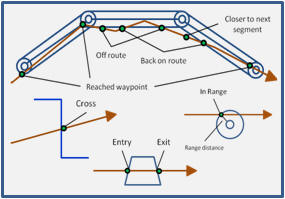
GeoDocent is a software application developed by CWS that supports the authoring, sharing, and presentation of multimodal guidance information (i.e. information in a visual, auditory, and/or tactile form) with geographical context. Authoring can be accomplished by direct annotation of a map to create specific "trigger spots/regions" or by defining more generic rules relative to classes of geometric regions (e.g. a circle around all buildings of a certain type). In April 2012, the original Microsoft Windows prototype of GeoDocent was evaluated at the United States Military Academy for it's potential to author and provide guidance to dismounted soldiers. A scenario was created to guide cadets through specific Areas of Operation (AOs). As the cadets were guided to each waypoint they also received geo-triggered messages on their entry or exit from predefined "virtual" boundaries, the relative location of fixed physical landmarks, and the location of particular types of simulated mobile enemy and friendly units.
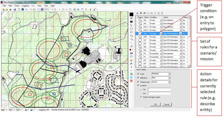
In Windows, Android, and Web versions, authoring can occur outdoors and tied to the author's current location automatically utilizing a GPS device, or it can be completed remotely. For each geographically triggered condition one or more actions is specified, such as show this image, play this video, play this audio, synthesize this speech, collect this information, or play this tactile pattern using a phone's tactor or an external array of tactors connected through a Tactile Control Unit.
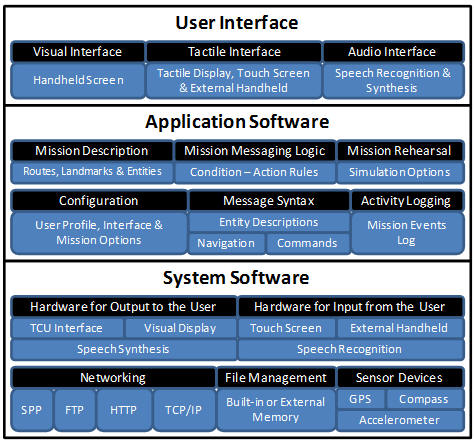
To facilitate situations where client-server communications are not practical/preferred, GeoDocent guides can be packaged (e.g. as a compressed set of XML files or as a GeoPackage). Because multimodal guidance with geographical context can be useful for a variety of user types (e.g. civilian, military, first responder) and applications (e.g. decision support, education and training, entertainment) a modular approach was taken to implementing domain ontology and application functionality so that "tailorization" is efficient. The architecture for GeoDocent is shown below.
Chapman, R. J., Riddle D. L., & Merlo J. (2009). Techniques for Supporting the Author of Outdoor Mobile Multimodal Augmented Reality. Proceedings of the Human Factors and Ergonomics Society Annual Meeting. San Antonio, TX.
< Products Overview HailDetected >
 
|
Copyright (c) 2006-2022, Collaborative Work Systems (CWS), Inc |